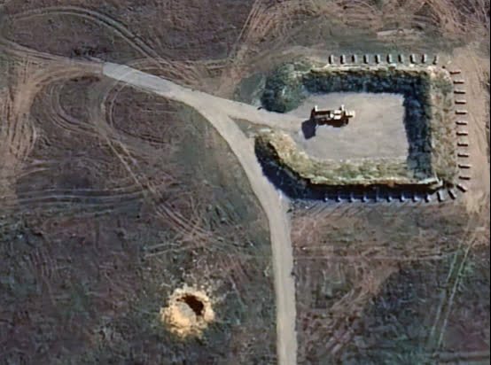
Google exposes Ukrainian military facilities

On November 3, Andrei Kovalenko, head of the Anti-Disinformation Center of the National Security and Defense Council of Ukraine, said in a Telegram channel that Google Maps published satellite images of Ukrainian military facilities after the update: “Imagine this situation. Google published updated images on the map, and the deployment locations of our military systems can be seen. We contacted them to quickly correct the situation, but they were on the weekend. They didn’t care about it.” Kovalenko said that Russian media have begun to “actively spread” these images. In particular, some pro-Russian channels have published screenshots of Ukrainian military facilities from Google Maps. An hour and a half later, Kovalenko updated that after the public reacted to the updated satellite images, Google representatives contacted the Ukrainian authorities, “and they said that they are already working to correct the situation regarding the images of the deployment locations of our military systems.” That night, screenshots of Google satellite maps circulated on pro-Russian Telegram channels, from which it can be seen that the location of the air defense system was exposed. For example, an air defense system can be seen in the photo of the Zhuliany Airport in Kiev, which the Telegram channel identified as a “Patriot” air defense missile system. According to the date annotation on the Google Earth service, the new satellite image was taken on September 28, 2023, while in the old images from October 2021 and April 2022, there is an empty field where the air defense system is located. In addition, there are photos of the Starokonstantinov Airport in the Khmelnytskyi region on the service, on which aircraft, hangars and other facilities can be seen. Google uses images from the American space company Maxar in its map service. In April 2022, Maxar management said that it was short of four satellites and planned to put more satellites into orbit to meet the needs of the US secret service for images of the Ukrainian territory. Maxar’s main customers – the National Intelligence Service (NRO) and the National Geospatial-Intelligence Agency – have more than doubled their purchases of satellite images of the Ukrainian territory since the beginning of the conflict. In February 2022, some Google Maps tools that provide real-time information on traffic congestion and the degree of crowding in various public places “to ensure the safety of local communities” were temporarily shut down.


